Nepal Floods 2026: Cause, Death Toll and India Risk
At 8:40 on a Wednesday morning, a mountain on the Nepal–Tibet border appears to have come apart. Ice and rock fell, a river was briefly corked, and a wall of slurry ran into Bhote Koshi and Trishuli. It tore through Gyirong port, the Miteri Bridge, Timure and Syabrubesi, the road used by Kailash Mansarovar Yatra groups and the Langtang trailhead. India rang Bihar and Uttar Pradesh because that water still had a name further down: the Gandak. The science is not closed. Check official live alerts, not a viral video.
Last verified: 29 August 2026, evening IST. Fast-changing figures below carry their own time stamp. Barrier-lake and missing-person numbers can move overnight.

AI-generated editorial illustration. It is not a live photograph or proof of the exact flood cause.
Quick Reply: Early science points to an ice-rock avalanche that blocked Lhende Khola, then burst into Bhote Koshi and Trishuli. India warned Bihar and Uttar Pradesh along the Gandak. It is not a proven GLOF. The mountain may still throw a second wave. Use live official alerts.
Need help now? Do not wait for an RTI reply.
- Indian nationals in Nepal: Embassy of India, Kathmandu, emergency/WhatsApp: +977 985 131 6807, +977 970 910 7500, +977 981 032 6117. Check the Embassy notice before calling because numbers can change.
- Nepal flood emergency desk: +977 974 444 1227 or +977 974 444 1228, 7 am to 10 pm Nepal time; [email protected]. Source: Nepal Ministry of Foreign Affairs.
- Immediate danger in India: dial 112 for police, fire, rescue or health help. Source: Government of India Emergency Response Support System.
- Live India alerts: open NDMA SACHET and follow your district administration. An old news post is not a live warning.
Nepal floods today: latest verified status
This is a time-stamped status, not a live control room. Always open the linked official source for a newer update.
| Question | Latest fact checked for this guide | Official source |
|---|---|---|
| When did the main flood begin? | Nepal's Home Ministry says the Bhote Koshi flood struck Rasuwa on 26 August 2026 at about 8:40 am. | Government of Nepal relief appeal |
| Which places were hit? | Nepal's 29 August briefing named response work in Rasuwa, Nuwakot, Dhading and Chitwan. An earlier official appeal also named Gorkha, while WHO also listed affected communities in Tanahun. | Nepal Foreign Ministry, 29 August briefing, Nepal Home Ministry and WHO Nepal |
| What is the latest official overall human-impact update used here? | At its 2 pm briefing on 29 August, Nepal's Foreign Ministry said 626 bodies had been recovered, about 2,400 people were still unaccounted for, and more than 4,450 people had been rescued, including more than 187 foreign nationals. It warned that the numbers can change as search and verification continue. | Nepal Foreign Ministry, 29 August briefing |
| What did the latest country-by-country tracker say about Indians? | The 28 August table listed 178 Indian nationals: 85 found and 93 still missing. That table covered foreign nationals, not every affected person, and it can change. | Nepal Foreign Ministry, 28 August update |
| Was India warned? | Yes. India's Home Ministry said a surge could travel downstream in the Gandak. Bihar and Uttar Pradesh were told to stay alert. The same 26 August bulletin said Nepal-side water levels were reducing and there was no panic-like situation at that time. | PIB and Ministry of Home Affairs, India |
| Is a second flood still possible? | Yes. ICIMOD warned of remaining hanging ice, unstable canyon walls, and a blockage still lodged on the Nepal–China border. Nepal and China have also reported new barrier lakes forming on the Lhende system after debris choked the river. That is a live secondary risk, not a closed story. | ICIMOD, 27 August update, Al Jazeera, 28 August |
Do not add Nepal and Tibet figures from different reports. Do not treat the foreign-national tracker as the total missing-person count. This page keeps each number with its date, meaning and source.
Nepal flood death toll: recovered, missing and rescued
Searches for nepal flood death toll, nepal flood death toll update and nepal flood today will show several numbers in the same week. They are not all the same thing.
Use the 29 August, 2 pm Nepal Foreign Ministry briefing as the overall official snapshot on this page: 626 bodies recovered, about 2,400 people still unaccounted for, and more than 4,450 rescued. That briefing warned the figures can change as search and identification continue.
The 28 August country tracker listed 178 Indian nationals: 85 found and 93 still missing. India's External Affairs Ministry later spoke of Indians who were still uncontactable. That is a different list from Nepal's missing-person tracker. Do not add the two together. Do not replace this dated table with an older news death-toll.
For a live answer, open the linked MOFA pages above. This wiki page is a time-stamped guide, not a control room.
Nepal flood cause, in 50 words
Early evidence points to an ice-rock avalanche high above Lhende Khola. Ice, rock and soil may have blocked the river for a short time. When water broke through, a fast wave of mud and boulders rushed into Bhote Koshi and Trishuli. Scientists are still checking the final cause using data.
Nepal flood map: the simple river path
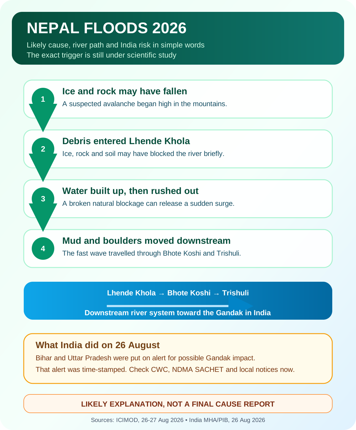
Simple infographic: what may have happened
| High mountain | Small river | Main Nepal rivers | India watch |
|---|---|---|---|
| Ice and rock may have fallen. | Debris entered Lhende Khola and may have made a short-lived blockage. | A fast surge moved through Bhote Koshi and Trishuli. | India watched the downstream system toward the Gandak. |
① Ice and rock fell → ② debris entered the river → ③ water may have built up → ④ the blockage gave way → ⑤ water, mud and boulders rushed downstream
Important: This is the leading early explanation, not a final investigation report.
Rasuwa flood map: Syabrubesi, Timure, Gyirong port and Miteri Bridge
The surge entered Nepal from the Tibetan side of the border and ran the only overland Kathmandu–Tibet corridor. If you are matching a rasuwa flood map or a gyirong port map to a clip, these are the names that keep recurring.
A ReliefWeb situation overview dated 27 August named the earliest heavy impact at Timure, Syabrubesi, and the Rasuwagadhi customs and border crossing, then Betrawati and Trishuli Bazar in Nuwakot, Galchhi in Dhading, and onward toward the Narayani.
Reporting after the event said the flood destroyed the Rasuwagadhi checkpoint and the Miteri Bridge (Sino-Nepal Friendship Bridge), swept through Timure, and hit Syabrubesi, the market town where the road ends and the walking trail into Langtang begins. ICIMOD's early science placed the ice-rock collapse on Lhende Khola, a tributary that joins Bhote Koshi near that crossing. Early notes put the blockage roughly 20 km upstream of the Miteri Bridge.
Gyirong port (also written Kerung, Jilong or Keyrung) is the Chinese immigration side of the same crossing. Search gyirong port flash flood or gyirong port before and after if you are matching a video to a landmark. Last year's 2025 flood hit the same bridge. A clip from 2025 is not proof of 26 August 2026.
What scientists know
The International Centre for Integrated Mountain Development, or ICIMOD is studying the event with partners in Nepal and China. Its early report gives a clear but careful picture:
- A very large amount of water, mud, sediment and boulders moved through the Bhote Koshi and Trishuli river system.
- Video and field information suggested that ice and rock debris may have entered Lhende Khola, a tributary of Bhote Koshi.
- The debris may have made a temporary natural dam. Water behind such a blockage can rise and then rush out if the blockage breaks.
- ICIMOD reported that the Trishuli level at Galchhi rose by as much as 9 metres in about 30 minutes, while Malekhu rose by about 7 metres over a similar period.
- Some river-monitoring stations were damaged or washed away. That makes exact measurement harder.
This explains why a flash flood can arrive with little warning. It is not only water. It can carry rocks, trees, mud and pieces of buildings at great speed.
GLOF Nepal or ice avalanche? What is still not proved
Three claims need special care.
Nepal's Foreign Ministry said on 29 August that the cause was not yet fully determined. The explanations below are therefore labelled as early evidence, not final findings.
1. Was it definitely a glacial lake outburst flood, or GLOF? Not yet. India's first bulletin used the words suspected flash flood/GLOF activity. ICIMOD's early scientific note focused on a possible ice-rock avalanche and temporary river blockage. A GLOF has a specific meaning: water suddenly escapes from a glacial lake. Until the investigation is final, it is safer to say flash flood with a suspected ice-rock-avalanche and blockage trigger.
2. Did an earthquake cause it? A magnitude 5.2 earthquake was recorded in the region around the time of the disaster. ICIMOD said unusual seismic signals were being studied, but no causal link had been established. Timing alone does not prove cause.
3. Did climate change cause this exact flood? Warming is changing snow, ice, frozen ground and mountain slopes across the Himalaya. That can raise long-term hazard. But ICIMOD said it was too early to say what role climate change played in this one event. The long-term risk and the trigger for one flood are not the same question.
The mountain that rang like a quake
For a few hours on 26 August, the machines said magnitude 5.2. The instinct is tectonic: a fault slips, a valley shakes, a slope lets go. Then the seismologists looked again.
The US Geological Survey, reported by the Guardian and CNN, later described that jolt as the signature of the collapse itself. A hanging mass of ice and rock had come away so violently that the ground rang. ICIMOD's first note was more cautious: unusual signals were recorded near Jilong, about 12 km away, and no causal link between a tectonic quake and the flood had been proved. Both statements can be true at once. The shaking was real. The story of what made it is still being written in satellite frames.
That is the curiosity at the heart of this disaster. In the high Himalaya, a glacier can impersonate an earthquake. The valley does not care what you call it. It only feels the slurry.
How a cascade is built
Disaster science has a cold phrase for what seems to have happened: a cascading hazard. One failure feeds the next until a quiet tributary becomes a moving hillside. Scientific American used that language for Rasuwa. ICIMOD's Saswata Sanyal put it in one sentence: a cryosphere event becomes a flood in a settlement within hours.
The working chain, from early field and satellite work reported by The Kathmandu Post and ICIMOD, looks like this:
- Bedrock lets go. ICIMOD cryosphere specialist Mohd. Farooq Azam told the Post the flood was triggered by a bedrock failure. When the rock under the ice failed, the glacier on top was swept with it.
- A hanging mass falls. Early imagery described a collapse on the order of 600 metres wide, from about 5,200 metres altitude, dropping more than 1,200 metres toward Lhende Khola. Treat those figures as early measurements, not a court exhibit.
- Ice turns into water on the way down. Friction cooks the falling ice. Soil, boulders and river water join the mass. What began as a slope failure arrives as a wet, heavy flow.
- The river is corked. Debris can jam a narrow gorge and store water behind a natural dam. When that cork fails, the stored water leaves almost at once.
- The wave outruns the gauges. ICIMOD reported about 9 metres of rise at Galchhi and about 7 metres at Malekhu in roughly half an hour. Some stations were simply washed away.
This is why “there was no heavy rain” is not a comfort. Rain-fed floods telegraph themselves. A cascade does not. The sky can be decent. The river can still arrive as a wall.
Same corridor, second round: ICIMOD noted that Lhende Khola has flooded twice in fourteen months. Last year's Rasuwa flood was later tied, by DHM and ICIMOD, to a supraglacial lake in Tibet — a true GLOF. This year's leading story is avalanche-plus-blockage. Two different triggers. One valley. That is the pattern to remember.
Second flood Nepal: barrier lakes and leftover ice
Search teams are still working. The mountain is still working too.
ICIMOD warned that a blockage remained lodged upstream on the Nepal–China border and that evacuation orders were in place for Jilong port. The Himalayan Times, quoting ICIMOD specialists, described two leftover threats: unstable canyon walls after a surge that scoured their toes, and the remaining mass of the Gangbhu glacier, where satellite images showed a steep collapse wall and a crack.
Then the river made new lakes. After ice, rock and mud choked the channel, Nepal's disaster authority and Chinese water officials reported barrier lakes filling on the Lhende system. Al Jazeera quoted Nepali researchers describing an avalanche-induced dam. A lake behind loose debris is not a reservoir. It is a pause.
If you are downstream, that pause is the whole warning. A barrier lake can overtop, cut a channel, or fail in minutes. Do not wait for a second newspaper headline. Watch Nepal DHM, NDMA SACHET and local orders.
Where else this kind of disaster can happen
The Himalaya is one machine. Ice, steep rock, narrow gorges and towns pinned to river terraces repeat from Kashmir to Arunachal, and from Khumbu to Kumaon. Rasuwa is a case study, not a one-off.
| Place and year | What science says | Why it rhymes with Rasuwa |
|---|---|---|
| Chamoli, Uttarakhand, 7 Feb 2021 | A rock-and-ice avalanche of about 27 million cubic metres from Ronti Peak became a debris flow that scoured valley walls and wrecked hydropower works. More than 200 people were killed or missing. Published in Science. | Same family of event: hanging ice and rock, not a classic lake burst. |
| South Lhonak, Sikkim, 3 Oct 2023 | Collapse of frozen lateral moraine into the lake made a ~20 m displacement wave, then a GLOF. About 50 million cubic metres of water left the lake. The Teesta III dam was destroyed. Published in Science. | Cascade plus infrastructure in the path. Rain helped. The trigger was still ice and moraine. |
| Kedarnath, Uttarakhand, June 2013 | Extreme rain, slope failure and the Chorabari lake / debris system on the Mandakini. Thousands dead. | Rain can finish what ice and loose moraine begin. Pilgrim towns sit in the same kind of slot canyon. |
| Thame, Khumbu, 16 Aug 2024 | ICIMOD recorded a GLOF from Thyanbo glacial lake that swept Thame. | Proof that Khumbu is in the same hazard family. |
| Bhote Koshi / Rasuwa, 2025 | DHM and ICIMOD later tied the previous Rasuwa flood to a supraglacial lake in Tibet. | Same river, different fuse, twelve to fourteen months earlier. |
A 2021 assessment in Mountain Research and Development mapped GLOF danger across the Indian Himalaya and found the largest counts of high-danger lakes in Jammu and Kashmir, then Arunachal Pradesh and Sikkim, with extra worry for roads, farms and hydropower. Transboundary lakes matter: water stored in Tibet or Nepal can still arrive in India. The Gandak warning of 26 August is that fact in real time.
If you draw the downstream map with a pencil, these names keep appearing:
- Koshi / Kosi — Nepal into Bihar
- Gandak / Narayani–Gandak — this event's India watch
- Karnali / Ghaghara
- Teesta — Sikkim and Bengal
- Sutlej, Chenab, Alaknanda, Mandakini, Dhauliganga
- Brahmaputra headwaters in the east
Hydropower, highways, army posts and homestays like the same river terraces that debris flows also like. That is not poetry. It is land-use.
How to tell a flood is coming when you are in the valley
There is no app that beats a roaring gorge. Use both.
What your senses can catch, if you are already there:
- The river drops without a dry spell. That can mean a dam is building upstream.
- Water turns grey, brown or black and smells of mud and crushed rock.
- A rumble like thunder travels up the valley with no storm overhead.
- Birds leave the river. Livestock refuse the bank. Locals start moving upslope. Follow them.
- A sudden wall of noise, then a rise measured in metres, not centimetres. You will not outrun it on the bank. You go up, not along.
What the official systems are for:
- Nepal live rivers and flood: Department of Hydrology and Meteorology
- India authorised alerts: NDMA SACHET
- India river forecast: CWC Flood Forecasting and the seven-day advisory
- Science desk on this event: ICIMOD Rasuwa note
- Nepal emergency desk and Indian Embassy numbers at the top of this page
Do not treat a WhatsApp clip as a timestamp. Match the landmark, the date, and an official notice. A real video from the wrong river is still a lie about this river.
Will the Nepal floods affect India?
There was a real downstream risk, but the warning was not a prediction that all of India would flood.
The flood moved through Bhote Koshi and Trishuli. India's Ministry of Home Affairs said the effect was likely to travel downstream in the Gandak river. It asked Bihar and Uttar Pradesh to keep border areas ready, with local administration, rescue teams and NDRF on alert.
The same bulletin, issued on 26 August 2026, said water levels on the Nepal side were reducing and the situation was under control at that time. That sentence must not be reused as a permanent all-clear. River risk changes with rainfall, upstream flow, embankment conditions and time.
For a decision right now, use:
- NDMA SACHET for authorised disaster alerts in India.
- Central Water Commission Flood Forecasting for river forecasts.
- Your state and district administration's current notice.
- Nepal Department of Hydrology and Meteorology for Nepal river watch and flood information.
What Indian families and travellers should do
If an Indian traveller in Nepal is missing
- Call the Embassy of India numbers shown at the top of this page.
- Also contact the Nepal emergency desk shown above.
- Give one clear set of details: full name, age, nationality, passport number if known, mobile number, travel route, hotel, vehicle details, last contact time and last known place.
- Keep a recent photograph ready. Send it only through an official channel when asked.
- Keep the caller's name, phone number and relationship ready.
- Write down when you called, which number answered and any reference number.
- Do not post passport scans or private phone numbers in public groups.
- Do not pay an unknown person who promises a rescue list, helicopter seat or faster embassy action.
If you are in a warned area in India
- Follow an evacuation order at once. Move to a higher, safer place by the route given by officials.
- Keep children, older people, persons with disabilities and animals away from floodwater.
- Do not walk, swim or drive through moving water.
- Stay away from electric poles, fallen wires, drains, culverts and damaged bridges.
- Keep medicines, drinking water, dry food, a torch, power bank, cash and copies of documents in a waterproof bag.
- Switch off electricity and gas only if officials say it is safe and you can do it without entering water.
- Drink boiled, chlorinated or officially declared safe water after flooding.
If you are a tourist, trekker or pilgrim in these mountains
The people who died on 26 August were not all locals. Foreign nationals are in the official tracker. River roads, border markets, hydropower camps and tea-houses sit in the same slot that a debris flow uses as a highway.
Before you go
- Buy insurance that actually pays for helicopter evacuation in Nepal, and carry a paper copy. A phone dies in a river.
- Register with your embassy. Indian nationals: keep the Kathmandu Embassy numbers in a notebook, not only in a phone.
- Share a live location and a written route with one person who is not on the trip.
- Check DHM the night before and the morning of every river-corridor move. Monsoon and post-monsoon are not “off season” for ice.
What to carry in a dry bag, not in the suitcase
These steps sit on NDRF flood guidance plus ordinary mountain sense:
- Passport, visa, insurance, cash, copies — in a waterproof sleeve
- Head torch, power bank, whistle
- Water purification tablets or a filter; floodwater is not drinking water
- One day's dry food, essential medicines, blister kit
- Warm layer even in August. Wet and windy kills faster than cold alone
- A written list of blood group, allergies, and two phone numbers
Where not to sleep, stand or film
- Not on a river terrace, dry island, sandbank or “short-cut” boulder field
- Not under a fresh landslide scar
- Not on a bridge to get the shot
- Not in a vehicle on a flooded road. Knee-deep moving water can take a car. NDRF says do not walk or drive through it
- If the river falls suddenly, leave the bank. That drop can be the dam forming
If the wave is already in the valley
Go up the nearest stable slope. Do not run downstream “to the next village”. Do not enter the water to save a bag. After it passes, treat every cut as dirty. WHO's Rasuwa note is blunt about water, sanitation and health services failing together. See WHO Nepal.
Langtang, Gyirong/Rasuwa Gadhi, the Bhote Koshi highway, Trishuli towns, Kedarnath–Badrinath, Chamoli side valleys, Teesta and the Khumbu river trails all share this geometry. The map changes. The rule does not: sleep above the roar.
These safety steps follow NDRF flood guidance.
Kailash Mansarovar Yatra: Indians missing in Nepal flood
Many of the Indians families are searching for were on the Kailash Mansarovar Yatra overland through Nepal. That route uses the Rasuwagadhi–Kerung crossing: Kathmandu to Syabrubesi, then Timure, then on foot across to Gyirong port in Tibet.
Reuters reported families and tour operators losing contact with groups on that route. The BBC described groups leaving Kathmandu for Syabrubesi, clearing Nepal immigration, and waiting to cross into Tibet. NDTV reported pilgrims last located at the Gyirong immigration facility, with an itinerary through Timure and Rasuwa toward Kathmandu.
Keep the numbers with their labels:
- Nepal MOFA 28 August foreign-national tracker: 178 Indians, 85 found, 93 missing.
- Indian MEA statements in the days after spoke of Indians who were still uncontactable. News reports put that figure above 300. Uncontactable is not the same as confirmed missing, and it is not the same as Nepal's recovered-body count.
If someone you know was on a Kailash group: use the Embassy numbers at the top of this page, give one complete information pack, and do not pay a stranger who promises a rescue list.
On X, families and news desks have used #NepalFloods, #Rasuwa, #BhoteKoshi and Kailash Mansarovar. A hashtag is not an official casualty list.
Langtang valley flood and Gosainkunda trek
Syabrubesi is the usual road-head for the Langtang valley trek. The same corridor is used by people heading toward Gosainkunda (Gosaikunda). The flood hit the road and river towns, not every trailhead in Nepal.
Treat Rasuwa as a disaster zone until local authorities say otherwise. Kathmandu, the airport, and treks on other ranges were not in this river's path. That does not make a booking through Syabrubesi “open”. Check official notices and your operator, and do not drive into a closed corridor to see the flood.
Bhote Koshi flood video: what Nepal flood footage can prove
Searches for nepal flood video, nepal flood today video, nepal flood footage and bhote koshi flood are filling with clips. A real video can still be the wrong day, the wrong river, or last year's flood on the same Miteri Bridge.
Before sharing:
- Match a landmark: Miteri Bridge, Rasuwagadhi customs, Timure, Syabrubesi, Gyirong port, or a named hydropower site
- Match the date: 26 August 2026, morning
- Match an official notice: Nepal Home Ministry, MOFA, ICIMOD, or India's PIB / Home Ministry
This page does not host unverified clips. Use them as questions, not as proof of cause or of a death toll.
Health risks after the flood
WHO reported damage to homes, roads, bridges and health services. It said around 10,000 households were reported to need immediate relief, and that damaged water, sanitation and health services could increase health risks.
In simple terms:
- Treat floodwater as dirty. It may contain sewage, chemicals, sharp objects or live electricity.
- Use safe drinking water and covered food.
- Clean a wound quickly and seek medical care for a deep cut, fever, breathing trouble, vomiting, diarrhoea or snakebite.
- Do not use wet electrical equipment until it has been checked.
- Return to a damaged house only after local officials say it is safe.
- Children should never play in floodwater.
Source: WHO Nepal flood and health response and NDRF flood safety guidance.
Legal position in India: emergency first, RTI later
The Right to Information Act, 2005 applies to records held by Indian public authorities. It does not turn Nepal's government into an Indian public authority.
An Indian citizen may later ask the Ministry of External Affairs, Ministry of Home Affairs, Central Water Commission or another Indian public authority for existing records such as:
- copies of public flood advisories received or issued
- dates and times when warnings were passed to states
- public evacuation directions and aggregated response figures
- copies of final assessment reports, when available
- records showing how public helplines handled the event, with personal details removed
Ask for records, not a new scientific opinion. In CBSE v Aditya Bandopadhyay, (2011) 8 SCC 497, the Supreme Court explained that RTI gives access to available records; a public authority does not have to create new analysis, draw inferences or give advice. The Court repeated this principle in CPIO, Supreme Court of India v Subhash Chandra Agarwal, judgment dated 13 November 2019.
Section 7(1) has a 48-hour rule where information concerns life or liberty. But an RTI application is still a request for information. It is not a rescue call. Use emergency numbers first.
Some diplomatic, security or operational records may be protected by Section 8(1)(a). Section 10 allows a public authority to remove an exempt part and give the rest where possible.
Step-by-step: choose the right action
- Someone is in danger now: call the Embassy, Nepal emergency desk or India's 112, as relevant.
- Your area has a warning: read NDMA SACHET and district notices, then obey evacuation instructions.
- You are checking a rumour: look for the same claim on Nepal MOFA, Nepal Home Ministry, India PIB/MHA, CWC, WHO or ICIMOD.
- A family member is missing: send one complete information pack through official channels and record the reference.
- You need records after the emergency: identify which Indian public authority holds them and file a narrow RTI request.
- No RTI reply arrives in time: use a first appeal under Section 19(1). Do not send repeated rescue requests through RTI.
Details to keep ready
For an emergency or missing-person enquiry, keep:
- full name and nationality
- passport or identity number, kept private
- Nepal and India mobile numbers
- travel route, hotel, guide and vehicle details
- last known location, date and time
- a recent clear photograph
- medical needs, if any
- your name, relationship and contact number
- call log, email copies and reference numbers
For a later RTI request, keep the official alert date, name of the authority, subject of the record and the exact date range. A narrow request is easier to search and answer.
Common mistakes
- Asking “Why did the flood happen?” Section 2(f) covers information in records. Ask for the final technical assessment, satellite analysis or advisory already held by the authority.
- Using Indian RTI to demand records from Nepal. Sections 2(h) and 6 concern Indian public authorities and requests to their information officers. Ask Nepal's official body through its own process.
- Treating the 48-hour rule as an ambulance. The life-or-liberty proviso to Section 7(1) is about urgent information. It does not replace the Embassy, police, disaster control room or 112.
- Demanding every confidential operational message. Section 8(1)(a) can protect information affecting security, strategic interests or relations with a foreign state. Ask for public advisories and use Section 10 for severable parts.
- Forwarding a dramatic video without checking its date. A video can be real but from a different river, year or country. Match landmarks, upload date and an official notice.
- Calling the event a proven GLOF, earthquake disaster or climate event. Early hypotheses are not final findings. Use the words suspected, likely and under investigation where the source does.
Real event: what India did on 26 August
At 9:08 pm on 26 August 2026, India's Ministry of Home Affairs published a notice after a Central Water Commission advisory. It said the Nepal surge could travel toward the Gandak. The Home Minister spoke with the Chief Ministers of Bihar and Uttar Pradesh. Border administrations, rescue teams and NDRF were put on high alert. The same notice said Nepal-side water levels were reducing and there was no panic-like situation at that time.
This real event shows the correct order: scientific alert → government warning → local preparation → public action. It does not prove that every place downstream flooded.
Source: PIB, Ministry of Home Affairs, 26 August 2026. The source did not publish a response cost, so this guide does not invent one.
Sample RTI letter for Indian records after the emergency
Use this only after urgent rescue and safety needs are handled. Send it to the Indian public authority most likely to hold the records.
To: The Central Public Information Officer
[Ministry of Home Affairs / Ministry of External Affairs / Central Water Commission]

Subject: Records on the 26 August 2026 Nepal flood alert and downstream warning

Under Section 6(1) of the RTI Act, 2005, please provide:

1. A copy of each public or technical advisory received or issued by this public authority on 26 and 27 August 2026 about downstream flood risk from Nepal toward the Gandak.
2. The date and time when each warning was sent to Bihar and Uttar Pradesh.
3. A copy of each public evacuation or safety advisory issued by this public authority.
4. The final technical assessment report, if it exists on the date of reply.

Please remove any exempt part and provide the remaining record under Section 10.
If another public authority holds an item, please transfer that item under Section 6(3) and inform me.
Please reply within the period in Section 7(1). If information is refused, please give the exact exemption and first-appellate details for Section 19(1).
Use the AI RTI Drafter to turn the points into a clean request. If the reply is late or incomplete, use the First Appeal Builder. Check a received reply with the PIO Reply Checker.
Frequently asked questions
What caused the Nepal floods in 2026?
The leading early explanation is an ice-rock avalanche high near Lhende Khola. Debris may have blocked the river briefly. When the blockage released, water, mud and boulders rushed into Bhote Koshi and Trishuli. ICIMOD says the exact trigger is still being studied.
Were the Nepal floods caused by a glacial lake burst?
That is not proved. India's first notice mentioned suspected flash flood/GLOF activity, while ICIMOD described a possible ice-rock avalanche and temporary river blockage. A final scientific assessment is still needed.
Did an earthquake cause the Nepal flood?
An earthquake was recorded near the event, but ICIMOD said no causal link had been established. Events happening near the same time do not automatically prove that one caused the other.
Will the Nepal flood reach India?
India's Home Ministry said a downstream effect was likely along the Gandak system and put Bihar and Uttar Pradesh border areas on alert. Its 26 August bulletin also said Nepal-side levels were reducing at that time. Check CWC, NDMA SACHET and local notices for the current risk.
Which Indian states were placed on alert?
Bihar and Uttar Pradesh were named in India's 26 August Home Ministry bulletin. This did not mean the whole of either state would flood. Local warnings decide which communities should move.
How can I check Nepal flood alerts live?
Use Nepal's Department of Hydrology and Meteorology, Nepal MOFA flood updates and local government notices. For India, use NDMA SACHET and CWC Flood Forecasting.
What should I do if an Indian is missing in Nepal?
Call the Embassy of India emergency numbers and Nepal's emergency desk listed at the top of this page. Give a clear information pack with the person's name, passport details, phone, route, last contact time and recent photo. Keep private documents off public social media.
Was the Kailash Mansarovar Yatra hit by the Nepal flood?
Yes, the overland Nepal route. Groups use Kathmandu–Syabrubesi–Timure–Rasuwagadhi, then Gyirong port in Tibet. That corridor was in the flood path. India's official Kailash routes through Uttarakhand and Sikkim are separate. Use Embassy numbers, not a tour-group rumour, for a missing pilgrim.
Is the Langtang valley trek or Gosainkunda open?
Syabrubesi is the usual road-head for both. Treat Rasuwa as a disaster zone until local authorities say otherwise. Other Nepal treks were not in this river's path. That does not reopen a booking through Syabrubesi.
How do I check a Nepal flood video or Bhote Koshi flood footage?
Match the landmark, the date (26 August 2026, morning), and an official notice. Last year's flood hit the same Miteri Bridge. A real clip from the wrong day is still the wrong story.
Are the death and missing-person numbers final?
No. Search and verification are continuing. This page labels its latest overall figures as the Nepal Foreign Ministry's 2 pm briefing on 29 August 2026. The Indian-national breakdown is from 28 August. Open the official links for a newer number.
How is this different from a glacial lake outburst flood?
A GLOF is a lake that was already there, then failed. This event's leading story is a slope that failed, then a river that was briefly dammed. Last year's flood in the same corridor looks more like a GLOF. Use the precise word only when the source does. ICIMOD has not closed the file.
Did the 5.2 earthquake start the flood?
Probably the other way around, if later USGS reporting holds: the collapse made the seismic signal. ICIMOD's first public note still refused a neat tectonic story. Until the joint Nepal–China investigation publishes, say shaking was recorded; the trigger is under study.
Where else in India could a similar cascade hit?
Any steep, glacier-hung valley with towns or projects on the river: Chamoli / Dhauliganga, Kedarnath / Mandakini, Teesta in Sikkim, parts of Jammu and Kashmir and Arunachal with high-danger glacial lakes, and transboundary rivers that begin in Nepal or Tibet. See the table above and the 2021 Indian Himalayan GLOF danger paper.
What should a tourist carry in a flood-prone Himalayan valley?
Waterproof documents, heli-rescue insurance on paper, torch, power bank, purification, medicines, cash, whistle, and a route shared with someone at home. Sleep above the river. Details are in the tourist section of this page.
How do I know a flood is coming if I am on a trail?
A sudden drop in the river, water turning to wet cement, a thunder-like rumble under a clear sky, and locals moving upslope. Then official feeds: DHM, SACHET, CWC. Do not wait to confirm on social media.
Can RTI be used during a flood emergency?
RTI can help obtain existing Indian government records later. It is not a rescue system. Call emergency services first. The Section 7(1) 48-hour rule concerns urgent information, not dispatch of a rescue team.
Can I ask India for the final flood report through RTI?
Yes, if an Indian public authority holds the report. Ask for a copy of an existing record and a clear date range. The authority may withhold exempt diplomatic or security parts under Section 8(1)(a), but Section 10 permits release of the separable remainder where possible.
Sources checked
Related on RTI Wiki
How this guide will be updated
- 30 August 2026: check for a newer Nepal MOFA status and CWC/NDMA alert.
- 5 September 2026: check search questions, official cause findings and broken links.
- 28 September 2026: replace early figures with the best consolidated official report, if released.
- Quarterly: recheck helplines, official links and internal links.
Reader signal
Was this article useful?
Tap once if it helped you. These counters show other citizens which pages are worth reading.